Denton, Maryland
| Denton | ||
| Land | ||
|---|---|---|
| Delstat | ||
| County | Caroline County | |
| Höjdläge | 13 m ö.h. | |
| Koordinater | 38°53′2″N 75°49′36″V / 38.88389°N 75.82667°V | |
| Area | 14,24 km² (2010)[2] | |
| Folkmängd | 4 848 (2020)[3] | |
| Befolkningstäthet | 340 invånare/km² | |
| Grundad | 1796[1] | |
| Tidszon | EST (UTC-5) | |
| - sommartid | EDT (UTC-4) | |
| ZIP-kod | 21629 | |
| GNIS-kod | 590087 | |
| Geonames | 4353075 | |
Översiktskarta | ||
| Wikimedia Commons: Denton, Maryland | ||
| Webbplats: http://www.dentonmaryland.com/ | ||
| Redigera Wikidata | ||

Denton är en småstad (town) i den amerikanska delstaten Maryland med en yta av 6,7 km² och en folkmängd, som uppgår till 2 960 invånare (2000). Denton är administrativ huvudort i Caroline County, Maryland.
Kända personer från Denton
- Sherman W. Tribbitt, politiker
Referenser
- ^ hämtat från: franskspråkiga Wikipedia.[källa från Wikidata]
- ^ United States Census Bureau, 2010 U.S. Gazetteer Files, United States Census Bureau, 2010, läst: 9 juli 2020.[källa från Wikidata]
- ^ United States Census Bureau (red.), USA:s folkräkning 2020, läs online, läst: 1 januari 2022.[källa från Wikidata]
Externa länkar
Media som används på denna webbplats
Författare/Upphovsman: AMK1211, Licens: CC BY-SA 2.0
Choptank River in Denton, Maryland
Författare/Upphovsman: Smallbones, Licens: CC0
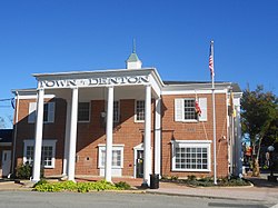
Town Hall in Denton, Maryland
This image is a copy of the official seal of the City of Denton, Maryland, as designed and adopted by the City in 1781. As such, any copyright is expired and is therefore in the public domain.
Författare/Upphovsman: Arkyan, Licens: CC BY-SA 3.0
This map shows the incorporated and unincorporated areas in Caroline County, Maryland, highlighting Denton in red. It was created with a custom script with US Census Bureau data and modified with Inkscape.


