Bray-sur-Seine
| Bray-sur-Seine | ||
| Kommun | ||
 Rådhus i Bray-sur-Seine | ||
| ||
| Land | ||
|---|---|---|
| Region | ||
| Departement | ||
| Arrondissement | Provins | |
| Kanton | Bray-sur-Seine | |
| Koordinater | 48°25′N 3°14′Ö / 48.417°N 3.233°Ö | |
| Yta | 2,15 km²[1] | |
| Folkmängd | 2 378 ()[2] | |
| Befolkningstäthet | 1 106 invånare/km² | |
| Borgmästare | Emmanuel Marcadet (2014–)[3] Emmanuel Marcadet (2014–)[4] | |
| Tidszon | CET | |
| - sommartid | CEST | |
| Postnummer | 77480 | |
| INSEE | 77051 | |
| Geonames | 3030460 | |
| OSM-karta | 1393025 | |
 Kommunens läge i regionen Île-de-France i Frankrike. | ||
| Webbplats: https://www.bray-sur-seine.fr/ | ||
.svg)

Bray-sur-Seine är en kommun i departementet Seine-et-Marne i regionen Île-de-France i norra Frankrike. Kommunen ligger i kantonen Bray-sur-Seine som tillhör arrondissementet Provins. År 2022 hade Bray-sur-Seine 2 378 invånare.
Befolkningsutveckling
Antalet invånare i kommunen Bray-sur-Seine
 Referens: INSEE[5] |
 En gata i staden
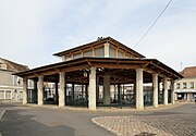 Saluhall
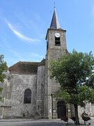 Sainte-Croix kyrkan
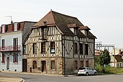 Korsvirkeshus
Se även
Källor
- ^ Répertoire géographique des communes, Institut national de l'information géographique et forestière, läst: 26 oktober 2015.[källa från Wikidata]
- ^ Populations légales 2022, Institut National de la Statistique et des Études Économiques, 19 december 2024.[källa från Wikidata]
- ^ läs online, www.data.gouv.fr , läst: 15 mars 2019.[källa från Wikidata]
- ^ Inrikesministeriet, Franska nationella registret över valda tjänstemän, läst: 15 mars 2019.[källa från Wikidata]
- ^ Chiffres clés - Évolution et structure de la population hämtat från the Wayback Machine (arkiverat 4 maj 2012).
Externa länkar
 Wikimedia Commons har media som rör Bray-sur-Seine.
Media som används på denna webbplats


(c) Katepanomegas, CC BY-SA 3.0
Ancient Coat of arms of France. Azure semy-de-lis Or.

Författare/Upphovsman: Eric Gaba (Sting - fr:Sting), Licens: CC BY-SA 4.0
Blank physical map of metropolitan France for geo-location purpose.
Scale : 1:14 816 000 (accuracy : about 3,7 km) for the bathymetry. More maps of France, view → Commons Atlas of France.

Shiny red button/marker widget. Used to mark the location of something such as a tourist attraction.

Författare/Upphovsman: Marc Ryckaert, Licens: CC BY-SA 4.0
Bray-sur-Seine (Seine-et-Marne department, France): the covered market

Författare/Upphovsman: Marc Ryckaert, Licens: CC BY-SA 4.0
Bray-sur-Seine (Seine-et-Marne department, France): timber framed house at the corner of the Rue de l'Abreuvoir and the Quai de la Gare

Författare/Upphovsman: Marc Ryckaert, Licens: CC BY-SA 4.0
Bray-sur-Seine (Seine-et-Marne department, France): the Rue Grande
Författare/Upphovsman: GFreihalter, Licens: CC BY-SA 3.0
Rathaus (Hôtel de Ville) in Bray-sur-Seine im Département Seine-et-Marne (Île-de-France/Frankreich)
_%c3%89glise.jpg)
Författare/Upphovsman: GO69, Licens: CC0
Église paroissiale Sainte-Croix de Bray-sur-Seine. (département de la Seine-et-Marne, région Île-de-France).
Författare/Upphovsman: Michiel1972, Licens: CC BY-SA 3.0
Population - Municipality code 77051.svg
Population Census 1962-2008Författare/Upphovsman:
|
Map data (c) OpenStreetMap contributors, CC-BY-SA _French_municipality_map.svg) • Shape files infrastructure: railway, highways, water: all originally by OpenStreetMap contributors. Status december 2011 *note: shown commune boundaries are from OSM dump May 2012; at that time about 90% complete |
Map of French municipality Bray-sur-Seine