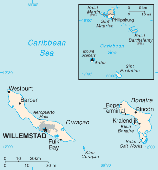
Netherlands Antilles-CIA WFB Map
Författare/Upphovsman:
CIA
Kreditera:
CIA, The World Factbook, 2005 http://www.cia.gov/cia/publications/factbook/maps/nt-map.gif
Kort länk:
Källa:
Upplösning:
326 x 351 Pixel (8142 Bytes)
Beskrivning:
Mapa Antillas Neerlandesas
Licens:
Public domain
Licenskommentaren:
This image is in the public domain because it contains materials that originally came from the United States Central Intelligence Agency's World Factbook.
Mer information om licensen för bilden finns här. Senaste uppdateringen: Mon, 05 Aug 2024 19:15:18 GMT