Muscovy 1390 1525
Författare/Upphovsman:
Dbachmann
Kreditera:
blank map: File:Europe location POR.png. Territorial boundaries based on File:Moscow1500.png, File:Kievan-rus-1015-1113-(en).png, File:Muscovy 1300-1462.png. See also File:Russia 1533-1896.gif.
See talkpage for discussion of the sources used. Information on historical territory relies on maps uploaded by ru:Участник:Koryakov Yuri (2008).
.png)
Kort länk:
Källa:
Upplösning:
440 x 425 Pixel (137834 Bytes)
Beskrivning:
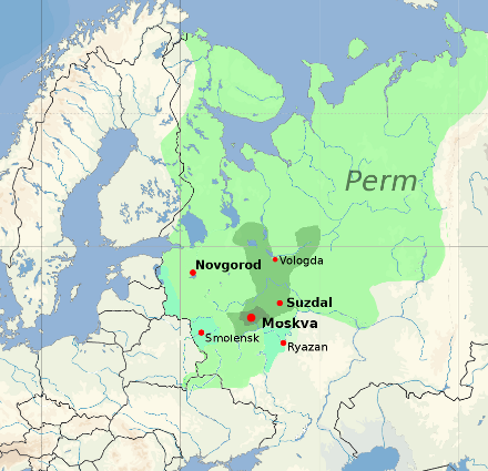
Territorial expansion of the Grand Duchy of Moscow, 1300–1547
Territory in 1300
Territory in 1389, after the final merging of Moscow and Vladimir
Territory in 1505, on the death of Ivan III
Territory in 1533, on the death of Vasily III
Modern national borders are shown for orientation.
Licens:
Attribution
Licenskommentaren:
derivative work based on the blank map by David Liuzzo.

|
Upphovsrättsinnehavaren till denna fil, David Liuzzo, tillåter vem som helst att använda den i valfritt syfte, förutsatt att lämplig hänvisning till upphovsrättsinnehavaren ges.
Vidaredistribution, redigering av verk, kommersiell användning och all övrig användning är tillåten. |
Erkännande:
David Liuzzo
|
Mer information om licensen för bilden finns här. Senaste uppdateringen: Tue, 14 Jan 2025 05:14:30 GMT